- Религиозная литература для детей
- История
- Животный и растительный мир
- Все обо всем. Универсальные энциклопедии
- Этикет. Внешность.Гигиена. Личная безопасность
- Популярная психология для детей
- Человек. Земля. Вселенная
- Наука. Техника. Транспорт
- Компьютер для детей
- Другое
- Путеводители для детей
- Спорт для детей
- Детская кулинария
- Программирование и электроника для детей
- Экономика и финансы для детей
- Земля. Вселенная
- Популярная анатомия для детей
- Популярная психология. Личная эффективность
- Биографии великих людей
- Занимательное языкознание для детей
- Мифология для детей
- Философия и право для детей
- Знакомство с профессиями
- Земля. Космос
- Занимательная математика
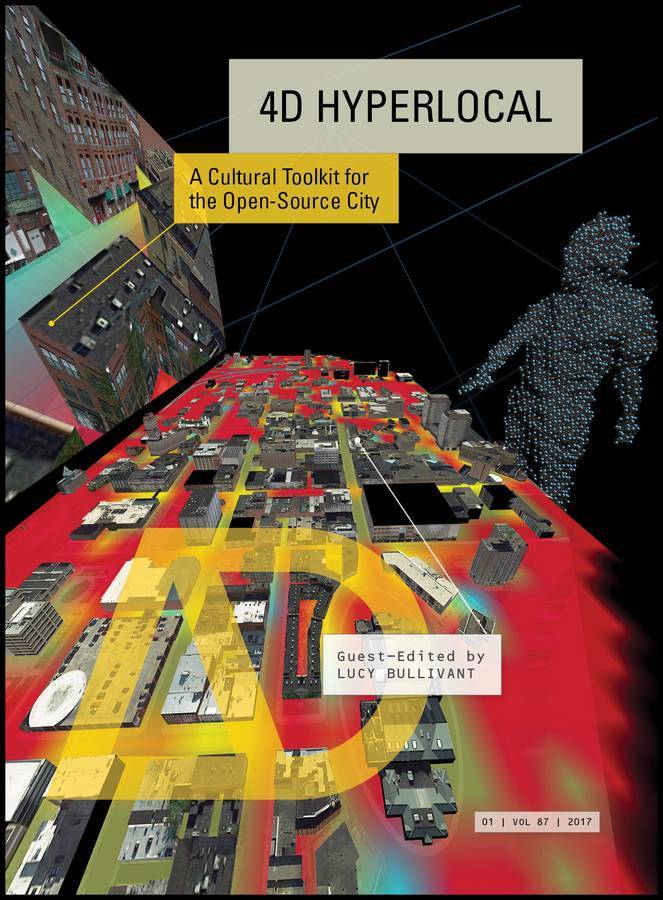
4D Hyperlocal. A Cultural Toolkit for the Open-Source City; John Wiley & Sons Limited
3475 р.
- Издатель: John Wiley & Sons Limited
- ISBN: 9781119097112
- Книги: Архитектура
- ID:6000505
Где купить (1)
Цена от 3475 р. до 3475 р. в 1 магазинах
| Магазин | Цена | Наличие |
|---|---|---|
Описание
4D Hyperlocal: A Cultural Tool Kit for the Open-source City The evolution of digital tools is revolutionising urban design, planning and community engagement. This is enabling a new ‘hyperlocal’ mode of design made possible by geolocation technologies and GPS-enabled mobile devices that support connectivity through open-source applications. Real-time analysis of environments and individuals’ input and feedback bring a new immediacy and responsiveness. Established linear design methods are being replaced by adaptable mapping processes, real-time data streams and experiential means, fostering more dynamic spatial analysis and public feedback. This shifts the emphasis in urban design from the creation of objects and spaces to collaboration with users, and from centralised to distributed participatory systems. Hyperlocal tools foster dynamic relational spatial analysis, making their deployment in urban and rural contexts challenged by transformation particularly significant. How can hyperlocal methods, solutions – including enterprise-driven uses of technology for bioclimatic design – and contexts influence each other and support the evolution of participatory architectural design? What issues, for example, arise from using real-time data to test scenarios and shape environments through 3D digital visualisation and simulation methods? What are the advantages of using GIS – with its integrative and visualising capacities and relational, flexible definition of scale – with GPS for multi-scalar mapping? Contributors: Saskia Beer, Moritz Behrens, John Bingham-Hall, Mark Burry, Will Gowland and Samantha Lee, Adam Greenfield, Usman Haque, Bess Krietemeyer, Laura Kurgan, Lev Manovich and Agustin Indaco, Claudia Pasquero and Marco Poletto, Raffaele Pe, José Luis de Vicente, Martijn de Waal, Michiel de Lange and Matthijs Bouw, Katharine Willis, and Alejandro Zaera-Polo. Featured architects and designers: AZPML, ecoLogicStudio, Foster + Partners, Interactive Design and Visualization Lab/Syracuse University Center of Excellence for Environmental Energy Systems, Software Studies Initiative/City University of New York (CUNY), Spatial Information Design Lab/Columbia University, Umbrellium, and Universal Assembly Unit.
Смотри также о книге.
О книге
| Параметр | Значение |
|---|---|
| Автор(ы) | Lucy Bullivant |
| Издатель | John Wiley & Sons Limited |
| ISBN | 9781119097112 |
| Форматы электронной версии |
Отзывы (0)
Добавить отзыв
Книги: Познавательная литература для детей, Культура и искусство - издательство "John Wiley & Sons Limited"
Категория 2780 р. - 4170 р.
Книги: Познавательная литература для детей, Культура и искусство
Категория 2780 р. - 4170 р.